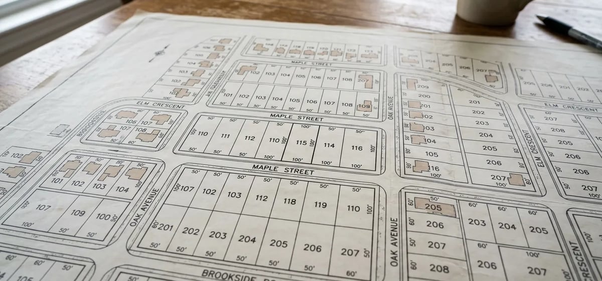
What Is A Plat Map?
A plat map is a detailed drawing created by a professional surveyor. It shows the exact legal property lines for your entire neighborhood. Think of it as a master blueprint for your subdivision. The word plat comes from the Old French word plate, meaning a flat piece of land. Over time in real estate, it evolved to mean a flat paper map that shows how a large piece of land is divided into smaller lots.
When you look at this document, you'll see the exact shape of your land. You'll also see street boundaries and shared utility spaces. It's a vital piece of paper to have when you are Buying a Home. The map clearly marks the dimensions of your lot, so you know exactly what you're paying for.
Why You Need To See It
You might think you know where your yard ends. Fences and hedges can be misleading. A plat map tells you the legal truth. You'll need to check it before you start any major outdoor projects. If you plan to build a new fence, add a shed, or put in a driveway, you must know your property lines. Building on your neighbor's land can lead to costly legal fights. You might even have to tear down your brand new fence.
The map also shows easements. An easement is a legal right for someone else to use a part of your land. For example, the city might have an easement to access a sewer line in your backyard. If you build a patio over that line, the city can rip it up to fix a pipe. You won't get paid for the damage. Checking your plat map before starting Landscaping, Drainage & Outdoor projects saves you a lot of headaches.
Your homeowners association might also ask to see your plat map before approving a project. They want to make sure your new deck or pool fits within the allowed space on your lot. You can find more details about these rules in our guide on Neighbors & HOAs.
Where To Find Your Plat Map
You usually get a copy of your plat map in your closing documents when you buy your house. If you can't find that paperwork, don't worry. You can easily get another copy.
- County Assessor Office: Your local county clerk or assessor keeps these records on file. Many counties now let you search for and download your map online for free.
- Title Company: If you bought the house recently, your title company can usually email you a copy of the map.
- Local City Hall: The zoning or building department at your city hall often has copies of neighborhood plats.
If you need to request a physical copy from a county office, expect to pay a small fee. This fee usually ranges from 5 to 25 dollars, though prices vary by location.
Plat Map vs. Property Survey
People often confuse a plat map with a property survey. They're similar but serve different purposes. A plat map shows the layout of an entire neighborhood or subdivision. It shows how the original developer carved up the land into individual lots. It gives you the basic dimensions of your property borders.
A property survey is a custom map made just for your specific house. A surveyor comes to your yard and measures everything. The survey shows your house, your driveway, and your fences. It proves exactly where your structures sit inside your property lines. If you look at the plat map and still feel unsure about your borders, you might need to hire a pro for a new survey. A land surveyor will mark the exact corners of your lot with metal stakes. Hiring a surveyor usually costs 400 to 900 dollars, but ranges vary based on lot size and local rates. This cost is worth it for peace of mind before a big project.
What To Look Out For
Reading a plat map can be a little confusing at first. It's full of numbers, lines, and surveyor symbols. Look for the bold lines that outline your specific lot. You'll see numbers next to these lines. These numbers represent the exact length of your property boundaries in feet.
You should also watch out for building setback lines. A setback line tells you how far away from the property edge you must build. For example, your neighborhood might require a 15 foot setback from the street. You can't build anything permanent in that space.
Keep a copy handy: Put a copy of your plat map in a safe folder with your deed and insurance papers. You'll be glad you have it ready when a fence contractor asks for it.